


GPS Map Camera (Google Map)

GPS Map Camera (Google Map)의 설명
The main feature of the 'GPS Map Camera':
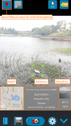
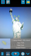
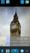
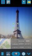
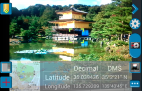
When you take a piture with GPS enabled, it will paste the google map and address name to picture. (GPS latitue/longitude also include in the information)
When you use this application, suggest to enable GPS. Belows are the stpes to enable GPS. (Almost the camera application need do the following to get GPS latitude/longitude)
1. Enable `Use wireless networks` and `Use GPS satellites` in `Location services` page.
2. Enable WIFI or 3G/4G network for fast locaton search.
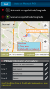
3. Enable GPS function in the camera application.
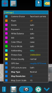
In the camera setting page, the similar functions will be grouped with the same color.
Now, Seperate the following groups if your device has support.
1. Flash
2. Scene/Exposure/White Balance/Color Effect/ISO.
3. Focus Mode.
4. Antibanding.
5. Picture Size/Picture Quality.
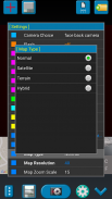
6. GPS Use/GPS Picture Save/Map Zoom Scale/Map Size.
7. Sound.
The color of function string is white as default. If change to another function, the color will change to grouped color. It's better to recognize what you set.
The focus and zoom when preview:
Focus: use one finger to touch the screen.
Zoom: use two finger to zoom in/out.
Others:
1. The picture saving time is more longer if the android version is below android-3.0.
2. The picture save to SD card (GpsMapCamera). Some device need a SD card.
3. In the outdoors, please set to "GPS Use" => "good GPS location"
"GPS use" => "roughly GPS location" can be used in indoor positioning is relatively fast.
But in some Android system, it seems have problem after using a period of time, you need to reboot to use it again.
Third party resources be used (The ownership is belong to them.):
1. Google map. (https://maps.google.com/)
2. Yahoo weather info. (http://weather.yahoo.com/)
3. Xda weather icon (http://cpanelcloudvps.com/xda-developers-view-single-post-util-spb-mobile-shell-301/)'GPS지도 카메라'의 주요 기능 :
당신이 사용할 GPS와 piture로 걸릴 때, 그림에 구글의지도와 주소 이름을 붙여 넣습니다. (GPS latitue / 경도 또한 정보에 포함)
이 응용 프로그램을 사용하는 경우, GPS를 사용하는 것이 좋습니다. belows로는 GPS를 사용할 수 있도록 stpes 있습니다. (대부분의 카메라 응용 프로그램이 수행해야 GPS 위도 / 경도를 얻기 위해 다음)
1. '위치 서비스'페이지에서 '무선 네트워크 사용'및 'GPS 위성 사용을`사용합니다.
2. 빠른 locaton 검색을위한 WIFI 또는 3G/4G 네트워크를 사용합니다.
3. 카메라 응용 프로그램에서 GPS 기능을 사용하도록 설정합니다.
카메라 설정 페이지에서는, 유사한 기능이 동일 색으로 분류 될 것이다.
장치가 지원이있는 경우 이제 다음 그룹을 별도의.
1. 플래시
2. 장면 / 노출 / 화이트 밸런스 / 컬러 효과 / ISO.
3. 모드 초점을 맞 춥니 다.
4. Antibanding.
5. 화면 크기 / 화질.
6. GPS 사용 / GPS 사진 저장 /지도 확대 배율 /지도 크기.
7. 소리.
함수 문자열의 색은 기본적으로 흰색입니다. 다른 함수로 변경하는 경우, 색상은 그룹화 된 색상으로 변경됩니다. 그것은 당신이 설정 한 것을 인식하는 것이 좋습니다.
초점과 줌 때 미리보기 :
초점 : 화면을 터치 한 손가락을 사용합니다.
확대 : 확대 / 축소 두 손가락을 사용합니다.
기타 :
1. 안드로이드 버전은 안드로이드 3.0 이하이면 사진 저장 시간이 더 길다.
2. SD 카드 (GpsMapCamera)에 저장 사진. 일부 장치는 SD 카드가 필요합니다.
3. 야외에서,에 "GPS 사용"=> "좋은 GPS 위치"로 설정하십시오
"GPS 용"=> "대략 GPS 위치는"실내 측위에 사용할 수는 비교적 빠르다.
그러나 일부 안드로이드 시스템에서는, 일정 기간 사용 후 문제가있는 것, 당신은 다시 사용하기 위해 다시 부팅해야합니다.
타사 리소스 (. 소유권이 그들에게 속해있다)를 사용할 수 :
1. 구글지도. (https://maps.google.com/)
2. 야후의 날씨 정보. (http://weather.yahoo.com/)
3. XDA의 날씨 아이콘 (http://cpanelcloudvps.com/xda-developers-view-single-post-util-spb-mobile-shell-301/)


